Wheeler Peak, New
Mexico, Thursday, October 17, 2013
Thursday morning I wake at dawn, reach for my phone and opened
the Taos webcam. I see blue sky and brilliant sunshine on big, snowy peaks, a
big change from yesterday when all I saw was a snow-blasted lens. Game on.
I was in Albuquerque for work and had a few hours Thursday afternoon
for a run up Wheeler Peak, the high point of New Mexico. My time was limited so
it would have to be a run, literally, or else I’d be descending in the dark. Not
that I had a problem with that but descending an unfamiliar mountain alone in
the dark, then driving two hours back to the hotel was not my best plan. I hoped to do Wheeler yesterday when I had
ample time due to a short work day, but I missed that chance due to an early
winter storm over the Sangre de Cristo
Mountains of northern New Mexico. Not wanting to believe the forecast, I watched
the Taos web cams all Wednesday morning hoping for breaking weather, but all saw
was that snow-covered lens. The forecasters pegged this one right. By noon I
realized my try for Wheeler was a bust so I opted for a run up the Sandia Crest
(see previous post). I was scheduled to fly home to Salt Lake on Friday so Thursday
was my last opportunity. Groggy and lying in bed early Thursday, I see that
sunshine from the webcam, and I’m elated knowing I have one last chance for
Wheeler.
My time was extremely tight; ditching work, changing in the hotel
room, a two-hour race up the highway while avoiding state troopers through Santé
Fe, Espanola and on to Taos. Add to that a quick trip to Big-5 Sports on the
way to the hotel for a pair of sweat pants to deal with the snow and cold
weather. The Thursday afternoon forecast called for sunny but cold weather at Taos’
10,000 foot elevation. All I brought from home was light running shorts, shoes
a tee-shirt and a cheap windbreaker. I almost went with just my running gear,
but in the end I grabbed some soccer sweats off the clearance rack at Big-5,
and they turned out to be a life saver.
All was going to plan until I reached the Town of Taos,
still 18 miles from the trailhead. It was there that I discovered I had lost my
wallet. The gas gauge showed less than a quarter tank, but no wallet in my
pocket. No cash in the console. No credit cards in the cup holder. I pull over
and look everywhere but my wallet is simply not there. Maybe I left it at
Big-5? In my hotel room? Maybe I just lost it? To be honest I was more frantic
about botching my attempt on Wheeler than losing my credit cards. The problem
was that I was over one hundred miles from the hotel, little gas and no money. Out
of desperation I went into a bank and ask if they can transfer money from my
bank. I know my account number, I know my pin, so I reasoned they could easily transfer
some funds. With no identification that teller just looks at me like I’m an
idiot, laughs and says “sorry”. I go back to the car and almost start back for
Albuquerque, but then the realization hits: I’m screwed anyway so I might as
well go climb Wheeler. I’ll deal with zero gas this later. I turn north and up
the canyon to Taos Ski area.
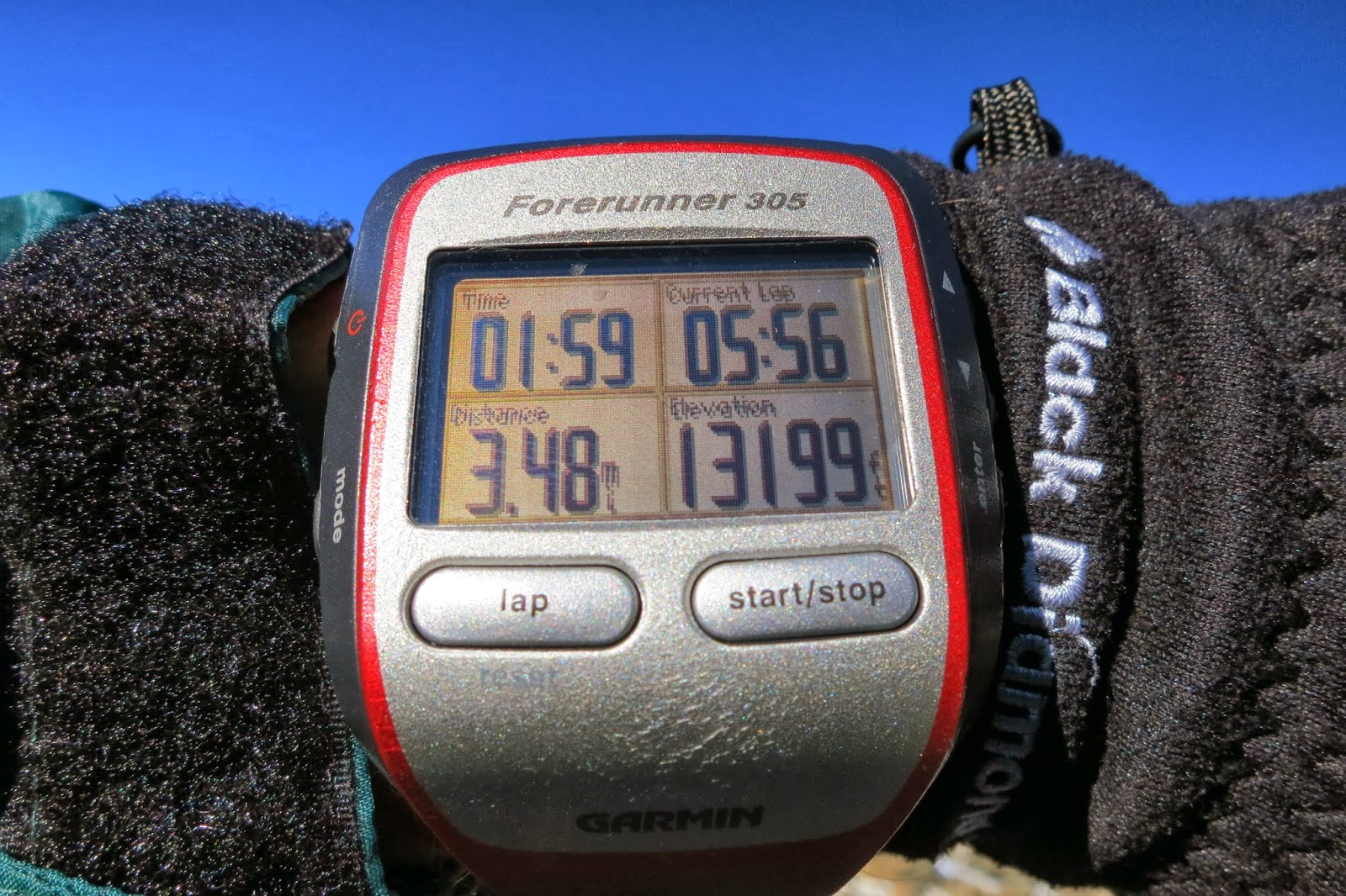
Wheeler Peak is 13,161 feet in elevation. It is located near
the Taos Ski area, which is about 18 miles from the town of Taos, which is about
130 miles, and over two hours of driving, from Albuquerque. The Williams Lake
route starts at 10,100 and the trail (new this year) has many switchbacks
making it about four miles one-way. The old, traditional route went straight up
a sub ridge from Williams Lake to a saddle just north of Wheeler Peak. Without the switchbacks the old route was
about three miles, one-way. I figured I could run most of the trail because the
new switchbacks take out the unforgiving angle. The route sounded like it’d be similar
to running up the service road at Snowbird, to the top of the tram, in terms of
both distance and elevation gain. I figured it’d be an easy run. Still I was
short on time. It would be a race to get up and down before sunset. I’d already
conceded that I’d be getting back to the hotel late, without dinner, assuming I
found someone to buy me gas.
From the ski area parking lot the trail head is still two miles
up a snow-covered dirt road. It really did snow here yesterday; it looked very
wintry, with about 4 inches at the base of the lifts. The snow is packed on the
road and kind of wet in the sun, but the rental car handles it without a
problem. At the trail head I sort through my Camelbac, load up my Snickers and look
through the pockets to make sure I have my windbreaker, gloves and headlamp. At
the bottom of the main compartment, nearly tucked under the bladder, I feel something
soft and round, like a hacky-sack. Not sure what it is, I pull it out to see it’s
my Australian coin purse (a Kangaroo body part). Inside I find 17 dollars and 40
cents. Maybe there is a God after all? Can I drive 120 miles back to
Albuquerque on just $17.40? Anything is possible with a little faith, and a Kangaroo
ball sack.
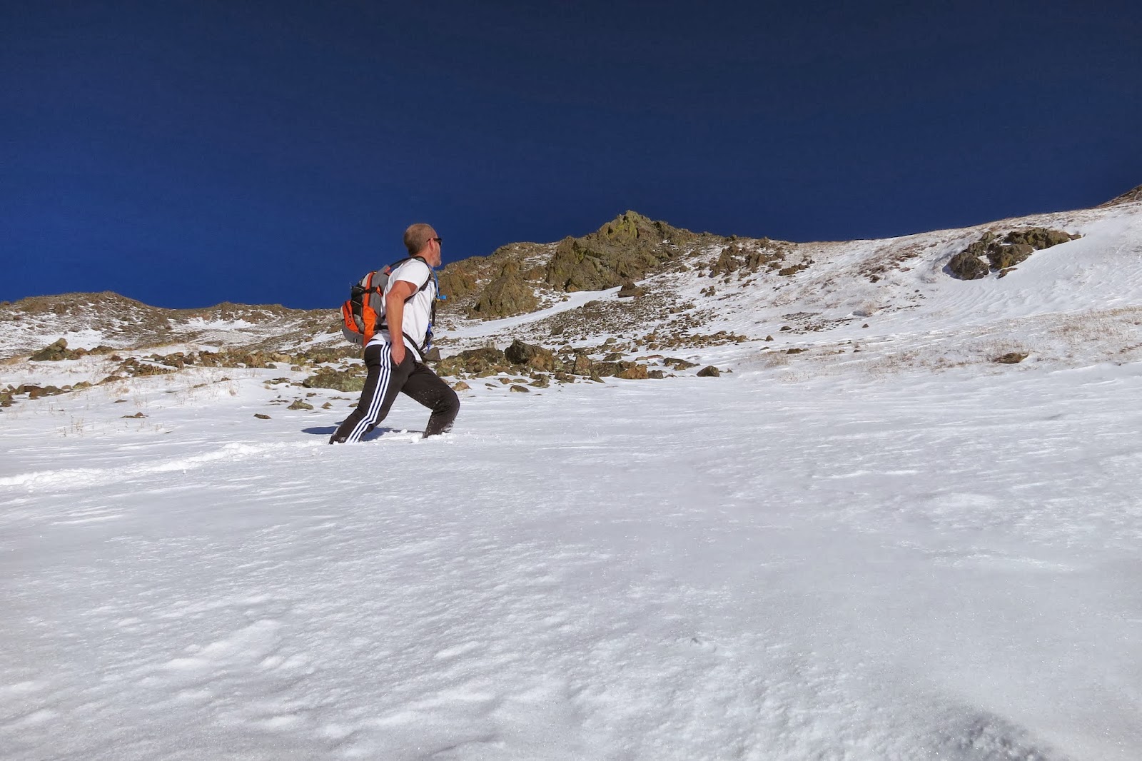
On the Williams Lake/Wheeler Peak Trail I run as best I can
through ankle deep snow. I’m not the first, several hikers have broken trail,
but it is a gentle incline and while the running is slow, my pace is steady and
it is not steep. My driveway is steeper. About half an hour later I meet two
hikers and they tell me the Wheeler Peak trail (the new trail) is just around
the bend, and sure enough, as I top a small rise there is the sign pointing east
into the forest towards Wheeler. One set of footprints marks the way. From the
junction I run up snow-hidden switchbacks, marked by blue-paint blazes on the
tree trunks. As I reach timber line the trail has disappeared under the snow so
I start straight up the mountain, first up a drainage then onto a minor sub
ridge. I meet another hiker who tells me I’m on the old ‘direct’ trail, but his
prints soon stop, apparently he wasn’t going for the top. I continue up and
every hundred yards or so I find old rock cairns along that sub-ridge. I assume
they are leading me to Wheeler. Above the forest, on the open slopes, the winds
pick up and the temperature drops. I’m getting cold and my fingers are soon
numb. My light jogging gloves offer little warmth.
I’m no longer running because it’s steep, but the pace is
quick and I cover elevation quickly. I reach a small saddle and the bright sun
on new snow, on big, stark mountains, is breathtaking. The scene fills me with
life and I no longer feel the cold. At that saddle I look north then south, small
peaks on either side, and I’m not sure which one is Wheeler. From the saddle the
northern peak looks higher, so I head north and soon reach a summit with a plack
marking it as Walter Peak, elevation 13,141 feet, the second highest point in
New Mexico. I turn around and look south, the next peak over must be Wheeler.
The two peaks are very close, not really peaks, more high
points along the ridge, and in five minutes I’ve covered the ground to Wheeler
Peak. Some ambitious souls have built a rock and concrete alter, complete with
a bomb-proof mailbox (a cast iron pipe,
10X30 inches) mounted inside the concrete. I’m now feeling really cold,
guessing that the wind-chill makes it sub-zero, and I sign the log with the
penmanship of a stoned Dennis Hopper while filming Easy Rider (he’s buried near
Taos by the way). I’m freezing and can only wonder how much colder I’d be without
those clearance rack, Adidas Futbol sweats? Truth be told, I love those things.
They might remind me of stupid soccer dads screaming at their kids, but they
are now my favorite mountaineering pant: light, warm, roomy where needed, form-fitting
everywhere else. Plus they really stopped the wind.
I stay at the summit just long enough to sign the log and take
a photo, but the wind and the cold soon force me down, and I’m racing the sun
and looking for relief from the icy gusts. Just off the summit I am nearly trampled
by six stampeding big horn sheep that
have ran up the steep eastern side of Wheeler, over the ridge just five feet in
front of me, and down the west side. It’s the closest I’ve come to getting run
over since I rode a Big Wheel in Kindergarten. (Not really, I’m a cyclist and
almost get run over every day.) As they run by I’m groping for my camera, but
they are long gone before my frozen fingers can turn it on. I never see them again,
even well below the ridge. Down into the forest I run down to Williams Lake. Sitting
at 11,000 feet, it is small and frozen, at the base of Wheeler’s southwest face.
It’s an easy run from here back to the car and I arrive just
as the sun is setting. My running shoes are soaked and I’m still freezing, so I
crank up the heat hoping for warmth as I drive that icy, dirt road back to the ski
resort base. I stop and call my wife to say everything is OK. She laughs when I
tell my tale of begging for cash at the bank. Everything is OK when I hear her
laugh. I drive to Taos and onto Espanola where the tank-empty-light finally
comes on. I fill it to exactly $17.40. those five gallons were plenty to get me
back to the hotel in Albuquerque. I arrive just before midnight, too late for
room service. My wallet was in my room, just where I left it, but I wasn’t
going back out for a Big Mac. Snickers and Mt. Dew were it.
 |


Owen, what beautiful pics and your trip description cracks me up! Sounds like it was quite the adventure!
ReplyDelete