Saturday, September 26, 2020

Mount Superior with Karly, August 2, 2020


Sunday's hike was up Mt. Superior from Alta with my daughter Karly. It's been a long, hot summer so we decided to go high to find some cool air, but apparently so did half of SLC. While driving up Little Cottonwood Canyon at 7AM, every trailhead was already overflowing. At the White Pine trailhead, likely at capacity all night, the cars were parked along the highway at least a half-mile both up and down the canyon from the turnoff. Gone are the days when I could pull into White Pine parking and find only two or three cars and I'd wouldn't see another sole while hiking the Pfeifferhorn. 

Karly is my third baby and second daughter, and she has given me two beautiful grand-babies, Harper and Madsen. Words cannot express the  joy that Harp and Mads bring me. In a world full of contention and endless bickering, even from friends that should be an ally, the love coming from a grandchild is pure, sweet joy. I'm in heaven when they run up spontaneously and bear-hug my legs. Hiking with my daughter is a distant second on the joy list. Sorry Karly, but it's your fault.  

American Fork Twin Peaks, the highest points in the central Wasatch (west peak 11,489ft, east peak 11,433ft). Timpanogos and Nebo are higher.


Pfeifferhorn (11,326 ft.), dead center. 


Fuzzy Pfeifferhorn, the Doug Fir sharp . . not the needles, just the photo. My Dad use to tell me the best way to determine if it's a fir, pine or spruce is to back into the tree. If you say SHIT! it's a pine or a spruce. If it feels soft and silky it's a fir.

Sorry for the repetition, the Pfeifferhorn view is stunning. The drainages seen here from Mt. Superior,   Red Pine, Maybird Gulch and Hogum Fork.

Beauty all around when I could stop looking at the Pfeiff . . .    

. . . but you know what captures my attention.


Karly high above Alta on the final approach to Mt. Superior's summit. We hiked the Little Superior ridge from Cardiff Pass. 


Humming Bird at 10,00 feet. How much more must they beat their wings in the thin air?


View into Cardiff Fork and Cardiac Bowl, the ski run dropping off the NE side of Mt. Superior. 

Daughter and her Dad.

Karly is the hero today! View SW from the summit of Mt. Superior (11,050 ft.), and of course the Pfeifferhorn just off Karly's elbow.

No joking about the crowds, those cars are the overflow from the White Pine trailhead. 

Two weeks out from surgery to repair a ruptured bicep tendon. The weird brace is to keep my arm from fully extending, bringing many stares and whispering from other hikers. "What the hell was that." Overheard after passing another group of hikers. 

Two hikers topping out on the south ridge of Superior, a classic Wasatch scramble. 


Yes Bishop, we did go to church today. 


Sunday, September 20, 2020

Finding my Dad's Arch, 45-years Later, July 28, 2020

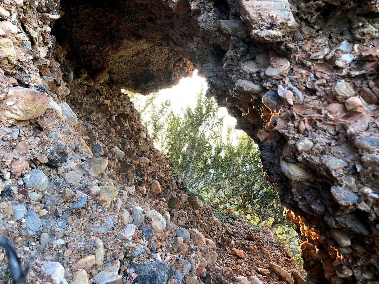
Dad's Arch, on the North Canyon/City Creek Canyon divide. Not much to look at but I've been searching for it for 45 years. My Dad spotted it years ago (early 1970's) while hiking with me and my brother Mark when I was about 10 years old and Mark about 11. We were hiking up the North Canyon trail when my Dad saw this hole in the rock from a quarter mile away.  It is rarely visible given the distance and its size (4 feet wide, 2 feet high, 4 feet long), it.can be spotted from the North Canyon trail for just a few minutes each day when the sun is at a perfect angle for a beam of light to shine through. Dad was ecstatic to see an arch high on the ridge above, in Davis County no less which is not known for its geography. Without the sun angle just right, it looks like nothing more than a small depression in the cliff. Of course my Dad had to go see it, so we bush-whacked up the steep slope to the ridge. Once there, Dad took a bunch of photos of Mark and I crawling through. It was just big enough for a kid to crawl through one at a time. My parents are now gone and I can't find those photos, likely buried in the storage of one of my siblings. 


Moon above Dad's Arch, from the same spot where my Dad spotted it so long ago from the North Canyon trail. 


Horned Toads everywhere near Dude Peak. 

View SW from Dude Peak.

View south from Dude, and the Central Wasatch.

View east, with Bountiful Ridge and Rudy's Flat just beyond the rounded, sunny peak.  


No wonder I thought the arch had collapsed. From 100 feet below while hiking the Dude Peak Trail, it looks like nothing more than just shadow on the rock, but it's there. 

The arch is the dark spot in the rock, and I've walked past it too many times while searching for it, too lazy to walk up a few feet investigate. Today I got ambitious and hiked up for a closer look, and BAM! There's Dad's Arch!  


Rudy's Flat.


I wish! I've seen bootleg graves in several spot along the North Canyon trail.

Tuesday, August 4, 2020

Free at Last! Cast Off, July 23; Hiking Dude Peak July 24, 2020


10 days after surgery and the cast is getting hold . .  and stinky. I tried hiking a couple of times, but it was quickly drenched in sweat which never really dried out.  
July 23rd Doctor visit, surgery follow-up and the stinky cast is gone, but WOW, my arm looks like that of an 80-year old man who never lifted more than a can of Diet Coke. 
Pilot hole drilled through Radius, with a larger diameter hole drilled half-way through the Radius for insertion of the torn end of the tendon into the Radius, held in place on the far side with a suture and a Titanium button inserted through the bone vertically then toggled horizontally against the underside of the Radius. The other four white lines are caps inserted into arteries for blood management.  


New splint is to hold arm at a maximum of 30-degrees past 90-degrees. 

I can't just sit on my ass for eight weeks while this thing heals. Biking is forbidden because a crash could snap the drilled Radius which would increase the magnitude of repair by 100, requiring major surgery and over a year to regain full use. As it, I'm eight weeks from full use. That said, hiking may not be great either because a fall could also snap the bone, but I haven't face-planted while hiking for years. It's a risk I'm willing to take. 

All the way up Dude Peak, and half way down, I kept hearing a low, barely-audible humming, and I kept wondering if it was sirens responding to a distant disaster or F-35s out of Hill Air Force Base on a west-desert bombing run, but half-way down I saw it, a flock of gnats hovering one to two feet over my head. When I moved, they moved, but always just over my head. Not sure why they were dogging me, but they never lit or bit, so no harm in having hiking companions.

Central Wasatch. High points, left-right starting in the middle of the photo, Dromedary Peak (11,107 ft.), O'Sullivan Peak/Sunrise (11,275 ft.),  Jenson's Folly (11,129 ft.), Broads Fork Twins (East Pk. 11,330 ft. - West Pk. 11,328ft), Pfeiferhorn's west-neighboring-peak (11,137ft), North Thunder Mtn. (11,150ft), South Thunder Mtn. (11,154ft).  


Dude Peak USGS marker and my brace with my cycling sun-shield acting as a compression sleeve to hold down the swelling. Sweaty, but otherwise the splint is not too bad. 

Fire Ant? I've seen these my whole life and have never identified these furry little beasts.  


Saturday, July 18, 2020

Peaks and Valleys, July 11, 12, 13, 2020

Life gives and life takes, and the year 2020 has been more of a taker, than a giver. . .

Saturday we went SUPing (stand-up-paddle-boarding) at East Canyon Reservoir, Sunday we went mountain biking on the "must do" Strawberry Narrows Trail (per utahmountainbiking.com) which is really on Soldier Creek Reservoir, not Strawberry, and Monday I had surgery to reattach my ruptured Distal Bicep Tendon, which I tore while BC skiing doing a kick turn in upper Mud Bowl of Farmington Canyon on May 17, 2020.


Saturday, July 11, 2020, SUPing at East Canyon Reservoir:


East Canyon Reservoir


Mt. Biking, Sunday, July 12, 2020, Strawberry Narrows Trail, Soldier Creek Reservoir:
Soldier Creek Réservoir

Strawberry Narrows Trail, named for the fjord-like water filled canyon that connect Strawberry and Soldier Creek. 

Fjords of Soldier Creek

The trail is quite narrow (not here) from overhanging grass and brush, a sign of lite use, which I'm all for, because it's all about 'dodging the herd.' 


Soldier Creek Reservoir peaking through the forest. It was a hot day (mid 90's) which made it tempting to jump in the lake, but we never did. 

The trail is rated "early intermediate" but it does have some short, loose, steep-ish ups and downs that we walked.   

Much of the trail is like this, a bit over-grown. 

This was as far as we rode, about 4.5 miles from the trailhead, due to Kara's front tire slowly going flat. To get this far we had already burned through three CO2 cartridges and we only had two more to get us back. As it was, two were not enough and we had to walk the last half mile because her tire was totally flat. Kara's mountain bike is tubeless and I did have an inner tube, but, by using C02, I hoped the Stan's would do its job and fill the leak, but it continued to leak. In fact, it seemed to get worse with every inflation. In hind site I just should've put in the inner tube because I hadn't added any Stan's since last fall, and it must been dry. I'm lazy at heart and didn't want to field dress the tire with a new inner tube - I was there to ride - and, with five C02 cartridges, I figured we had plenty to do the whole ride. So, instead of riding 24 miles we rode 8, and walked the last half mile.  


The crux of the trail (not pictured) was a very narrow, quarter-mile section that traverses a steep, open steep side-hill just above the water. When I say narrow, think of riding the top of the curb in front of your house. It's about an eight-inch wide single-track bordered by brush, and it trends downward due to the natural degradation of the overall slope. Any average rider can hold an eight-inch line, but when the consequences are serious an easy line can mess with your mind. A confident rider won't even hesitate and will ride it without a thought, but it was scary for one biker we passed who had dismounted and was walking that bit. In their defense, if your front tire happened to go off track you would probably yard-sale all the way down the steep slope to the water (think road-rash and trauma), all the way down to the water that drops off into inky-blackness, swallowing your expensive bike into the depths of Soldier Creek.  


Distal Bicep Tendon Reattachment, Monday, July 13, 2020:

I tore 99% of the Distal Bicep Tendon off the bone while doing a simple kick-turn. It happened while back country skiing in Farmington Canyon on Sunday, May 17, 2020. On a steep side-hill in upper Mud Bowl, due to brush blocking the way, I planted the left ski pole (downhill pole) behind me, twisting my upper body at the waste one-third the way around, set the right (uphill) ski as a platform, then attempted a kick-turn with the left (downhill) ski. When I kicked the lower ski around, the platform ski (right ski) suddenly slipped about six inches downhill as it wasn't set solidly (over confidence kills), that resulted in the left arm hyperextending behind me when my ski pole held firm in the wet, sticky snow. I've done this move thousands of times with no problems, so why this time? I'm sure it was the heavy, grabby, wet-concrete-snow that did not give. Colder, powder snow will always give way, even if just a bit.
When I slipped I heard an audible pop with immediate, intense pain. I thought I had broken the elbow, but later that day at the Urgent care, the X-rays confirmed no broken bones. Three weeks later I still had pain, and, while I could ride my bikes (road, mountain and gravel) and ski (two more powder days after the injury), I couldn't do simple things like pick up a gallon of milk, a basket of laundry or take out the garbage with my left arm. I went to a Sportmeds Doctor who ordered an MRI, which confirmed that most, but not all, of the Distal Bicep Tendon was torn off the bone. Almost two months after the injury I finally get it repaired, which will require eight weeks of rehab before I can return to normal activity. If it had broken, or torn 100%, the repair would have been easy to diagnose, and I'd likely be close to full recovery by now. Fence sitters never win.   
July 22 update: one more day and this thing comes off. Sweaty, itchy, and it's tough to type, put in my contacts, and among many other things. I need my left arm.