 |
| Grandest view in the world. |
SUP - Jackson Lake, Colter Bay, Friday, June 18, 2021
 |
| Jackson Lake |
SUP - String Lake and Leigh Lake, Saturday June 19, 2021
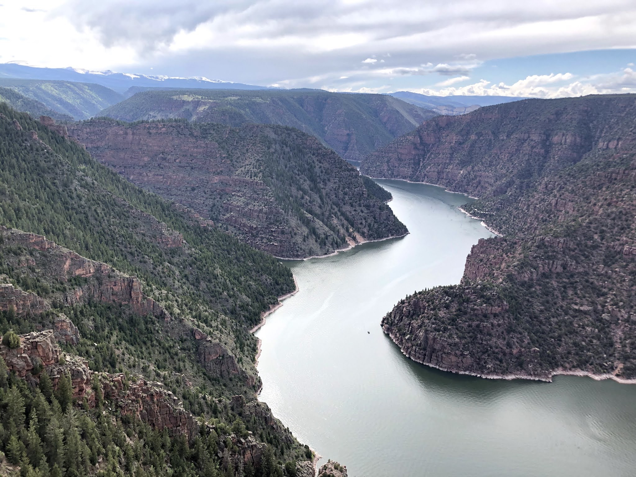
Given the chop on Jackson Lake yesterday, Kara wasn’t excited about paddling four miles, with a portage between the lakes. So I went early while Kara slept in. It was still early enough that there was ample parking at String Lake (an hour later and the parking would be impossible) and the water was glass, no wind, no chop. I paddled a mile to the north end of String Lake then did the portage over to Leigh Lake. The portage was much easier than I was told, only 300 yards through the forest on a wide, flat trail to Leigh Lake, and it was well worth it. Leigh Lake is big and there were only two other paddlers in sight. Leigh Lake can only be accessed by human power, so the effort to get there weeds out the 'riff-raff.’ The crowds stay on String Lake, most are unwilling to portage over to Leigh. The water on Leigh was smooth and calm, not even a hint of a breeze, and I paddled about a mile and half over to the point where Mt. Moran comes into full view. Far across I could see the scree slope that runs into the lake and where the CMC climbing route starts up Mt. Moran (CMC is the name of route, named for the first group to climb the route, the Colorado Mountain Club).
I climbed Mt. Moran about then years ago and it was a fantastic day of climbing. Although, the approach we chose was horrendous . . . and stupid. We didn’t rent a canoe to paddle to the base, instead we bush-whacked around the east and north sides of Leigh Lake. By the time we reached the trail at the base of Moran we were scratched, bloody, and already exhausted before even starting the 3,000 foot vertical climb up to the CMC camp. Paddling today reinforced how stupid it was to bush-whack around the lake. We camped at the CMC camp then, next morning, went up Drizzlepuss (rock tower mid-way up the CMC) then climbed the CMC just left (south) of the black dike that runs vertically up the face of Mt. Moran. While climbing the face of Moran, which is much like the West Slabs on SLC’s Mt. Olympus, only steeper and better rock, you are directly above the Falling Ice Glacier. While climbing we could hear it popping and groaning. I loved hearing that glacier, so unreal com ing from the hot, glacier free Wasatch Mountains.
I aimed to paddle to the base of the CMC, but I still had over half the lake to paddle, and I kept thinking "Kara would love this,” so I turned around to go persuade to come paddle. When I reached the truck and loading my SUP, there was a battle for my parking space, there was a long line-up of cars waiting for parking. Grand Teton National Park is really crowded along the roads and trailheads, but if one is willing to hike or paddle just a short distance, the crowds disappear. I drove back to Colter Bay to get Kara. I told her how much better is was than yesterday at Jackson Lake and she was game. When got back to String Lake (about noon) the parking lot was packed and we got in the queue. We were willing to wait, but if nothing opened in 20 minutes we were ditching the SUPs and going cycling. We only sat there about ten minutes until someone left, luckily we were in place to snatch it. Once on the water Kara loved it!Smooth glassy water, so nice given the windy chop we had on Jackson Lake. Although, while in the middle of Leigh Lake there was a weird micro-burst of wind, presumably from a thunderhead off to the west, and it almost blew us off our boards. For a few minutes there were big waves and a hurricane wind, then, as quickly as it came the wind and waves disappeared. Leigh was again dead flat and glassy. We rarely wear our life-jackets, we strap them to the boards for emergency use only, but this micro-burst was an eye-opener. If we had been blown off the boards it would have been impossibly to get the life jackets on given the panic of dropping into an icy lake. We agreed, next time we’re on open water we will wear the life-jackets.
Solo paddling on String and Leigh Lakes was beautiful, but it would’ve been better with Kara, . . .
 |
| This is the view of Leigh Lake near the portage to String Lake. There is about a mile of paddling over to the point (next to my right knee) and then about two miles across the main body of Leigh Lake to the base of the CMC climbing route, but, after paddling around the point to see the base of Mt. Moran (which is the high point to my right) I’m heading back to get Kara. |
 |
| Leigh Lake side of the portage, view north with Mt. Moran (l). |
 |
| String Lake side of the portage, view south. |
 |
| Portage. |
. . . . this time with Kara.
 |
| A mile across the south arm of Leigh Lake and around the point into the main body, with Mt. Moran straight ahead. The scree slope at the base of the CMC climbing route is the faint white diagonal line at waters edge in the middle of the photo. |
 |
| Mt. Moran overhead. |
 |
| Heading back around the point from the main body of Leigh Lake to the South Arm. |
 |
| The only way to improve upon the Tetons. |
 |
| South end of String Lake with the Grand Teton peaking out. the high peaks left to right: Teewinot, Grand Teton, Mt. Owen (barely seen), Storm Point, Mt. St. John and Rockchuck Peak. |

South end of String Lake with the Grand Teton peaking out. the high peaks left to right: Teewinot (peeking around the right side of my hat), Grand Teton, Mt. Owen (barely seen), Storm Point, Mt. St. John and Rockchuck Peak.
The big problem with the Tetons is I can’t stop taking photos. . .
After paddling, when the light was softening and the crowds gone, we drove to Jenny Lake and parked. If we had tried this an hour earlier parking would have been impossible. If you know Jenny Lake you know it is popular. During the day even the highway near the turn-off to Jenny Lake is lined with cars a half mile in both directions. At 6:00PM the parking lot is wide open. From Jenny Lake we rode the bike path to about two miles south of the Taggart Lake trailhead (11.5 miles total). Not a huge ride but big miles was not the point, riding at the foot of the Tetons at dusk is undescrabale. On the way back we rode into the Lupine Meadows parking lot, the trailhead for Garnett Canyon which is the access trail to the heart of Teton climbing, including the Grand Teton (O/S, Upper Exam, North Face, Black Ice Couloir (via a traverse of the Enclosure)), Mt. Owen, Middle Teton, South Teton, Ice Cream Cone, South Teton, Cloudveil Dome, Nez Perce, etc, etc. Parking there is tough too. Lupine Meadows parking is now even used by Jenny Lake desperados, they park then walk to Jenny Lake, about a mile north.


 |
| Mt. St. John (l) and Rockchuck Peak (r). |
Random shots (too many) from GTNP
 |
We rented the trailer, which we almost bought in February. It was nice for sleeping and showering, but it was a nightmare to tow. Although way under the Tacoma weight limit, we really struggled up the hills. We drove home via Tin-cup Pass/Soda Springs/I-15, and the speed limit on I-15 in Idaho is 80-mph. I could barely hit 75-mph on the flats. I’m not use to towing and this experience was hell.
|
 |
| Mt. Moran above Jackson Lake. |
 |
| Grand Teton above Jackson Lake. |
 |
| Mt. Moran above Leigh Lake. |
 |
| The CMC route is to the left of the Black Dike (the high point in photo). The CMC camp is located in the highest stand of evergreens in the middle of the photo |
 |
| Mount St. John (l) and Rockchuck Peak (r). |
 |
I’ve climbed the Grand Teton 20 times via several routes: Owen/Spaulding, Exum Ridge and the Upper Exum Ridge. Those are the easiest routes up the Grand and about my limit of alpinism. It’s tough to hone those skills when sitting at a computer 24/7. But those “easy" routes are not a walk in the park, it’s a different world to climb a 5.5 grade route (difficulty rating) with huge exposure versus little exposure in the Wasatch. I have a co-worker who climbs 5.12 in Little Cottonwood Canyon, but when we climbed the Grand via the “easy" 5.5 Upper Exum, he was reduced to tears. The huge drop-offs totally freaked him out. He normally leads me up everything, but on the Grand our roles were reversed, I led every pitch. The huge exposure didn’t bother me and it’s a joyful feeling to climb an exposed ridge on a big mountain far above humanity.
I’ve also climbed Teewinot 10 times and Mt. Owen once. My favorite Teton Climb is Mt. Owen, it has no crowds, it has great rock, it has fun route-finding which is not obvious, so it’s still adventurous, plus it’s fun camping on the Teton Glacier at the base of the North Face of the Grand. |
 |
| Teewinot (l), Grand Teton (middle), Mt. Owen (r). |


