The Pioneer Mountains, east of Hailey, Idaho are big, beautiful mountains, with a population base of less than 40,000, compared to the Wasatch’s 2-million. Do the math, there’s a reason for the two-hour traffic jams in Little Cottonwood Canyon after each 2-inch dusting of powder.
The Pioneers don’t get as much snow as the Wasatch, but, in my mind, the lack of crowds is a welcomed trade-off. Today there was about 20 inches at 8k feet, mostly supportable crusts with a corn-ish surface, which offered very fun skiing, but when those crusts broke I sank right to the ground. Under the crust is totally rotten snow with nothing to support a 155 pound skier. If I lost 10 pounds maybe I wouldn’t break through? (Philosophical questions abound.) I only broke through the crust a few times, once tripping me, resulting in a somersaulting-yard-sale, but no injuries and, more importantly, no damage to skis, no core-shots. Even with a thin snowpack, the skiing is good in the Pioneers.
 |
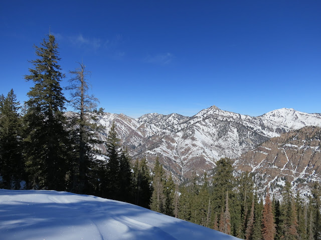
| Idaho has big, impressive mountains that get very little attention, unlike lesser mountain ranges such as Utah’s Wasatch, which is over-hyped, over-developed, over-photographed and thus way over-used. This is Cobb Peak (10,650 ft) viewed from near the junction of the Hyndman Creek trail and the Johnstone Creek Trailhead, which is about a half-mile from (east) the winter trailhead, which is about a mile down (west) of the summer trailhead because the road is not plowed. Cobb has a vertical rise from its base at Hyndman Creek to the summit of nearly 4,000 feet with a continuous (no flats) slope of over 35 degrees. In comparison, the Wasatch is known for its stair-stepped topography, 1,000 foot steep drop then a 1,000 feet of flat-ish slopes, repeat. The Pioneer and Sawtooth Mountains are icons of continuous angles, with no crowds. |
 |
| Johnstone Creek trail, a half mile from the winter trail-head. |
 |
| Trashy parents make trashy kids who become trashy parents . . . the cycle lives. |
 |
The conspiracy against e-bikes continues, based on weak personalities and misinformation. Face it, the greatest damage to a trail occurs when a rider (power assisted or free-pedaling) descend too fast, lock their brakes and skid, thereby trenching the trail. With the next big rain the trail erodes even more, by a factor of ten. It begins with poor bike handling, skidding down a trail with big knobby tires, and the trenching happens. Skid-mark riders are the problem, not E-bikes.
Anyone who knows anything about cycling knows that Class-1 E-bikes do no more harm to a trail than a regular bike, except for maybe damaged egos of free-peddlers who can’t handle getting schooled. Simply put, the tires of a Class-1-E-bike DO NOT spin when the pedal-assist engages. It is NOT like a motorcycle or a Polaris side-by-side with huge engines and instant acceleration. The pedal assist of an E-bike is akin to a strong tail-wind but only when you mash the cranks. No spinning and no trail damage is possible. Ignorance may be bliss, but truth shall set you free.
Just know, one day your wife, or significant other, or perhaps even you, will stop riding because pedaling becomes a painful grind. But someday when your wife, significant other, or perhaps even you, gets an E-bike, your world will transform, you/they will again feel the joy and freedom of riding a bike in the mountains, without your lungs exploding. Your wife will start riding with you again and you will thank God for e-bikes, with ZERO damage done to the trail.
Free the trail and your mind will follow!
|
 |
| Cobb Peak (r), 10,650 feet. |
 |
| Another trailhead another mile up the trail. Apparently the road I’ve been skinning the last two miles is open to autos in the summer, but it's not plowed in the winter. That's OK, it keeps to maddening crowds at bay. |
 |
| Ski lines everywhere you look. North Hyndman Creek straight ahead. I ascended up the divide on the left (above my left ski tip), the divide between North Hyndman Creek and Button Creek. |
 |
| North facing avalanche paths make great ski lines. The Pioneer Mountains east of Hailey/Ketchum are a cornucopia of ski lines. |
 |
| Up on the Button Divide I skinned by this Moose bed, on the bare ground against a sheltering boulder, much warmer than sleeping on the snow. Moose aren’t stupid. |
 |
| Moose boulder with the North Hyndman vs. Hyndman Divide above. |
 |
| Button Creek Peak? It’s listed as point 9,270’ on the map. |
 |
| Looking back (west) the way I came, down North Hyndman creek drainage towards Triumph, Idaho. |
 |
| Fun corny turns, until the crust breaks. |
 |
| I love my BD Helio 88s (skis) with Atomic Backland Carbon Pros (boots). Light and high performing, more than their size and weights might suggest. |