 |
| Black's Peak from top of Rectangle Peak (8,400 ft.). |
What a strange winter. Jackson has more snow than Alta, and even a consistant under-achiever like Sun Valley has more than Park City; no one has much to brag about.
My local, “private hill”, was un-skiable until the storm cycle of January 20-24. So lean in fact, I could run to the Rudy’s Flat (7,130 ft.) - in running shoes - on January 14th, and found only 14 inches of snow. In January of ’11 there was 52 inches. R.F. is the staging area for skiing Bountiful Ridge. The ridge has an endless array of drainages and bowls, the only limiting factor is one’s energy to hike in and hike out. The runs start out short and steep but get progressively longer the further one hikes the ridge; anywhere from 500 vert. to 2,000 vert. However, there are barriers to entry. The BIG drawbacks to B-Town Ridge are: (1) Long approach – five miles and 3,000 foot gain - one-way - to the nearest and shortest lines; (2) Brush! Trailhead is at 5,500 feet – oak brush city!; and (3) no easy way out. For the bigger lines, one must traverse several miles of the ridge, approach your line from the top, and thereby dropping in blind as far as stability and snow quality go. Further, the big lines are surprisingly remote considering the smog and drone of traffic of SL and Davis Counties are never out of eye or ear shot. But don’t let the humanity fool you, they are remote and they are a locked system. There is no easy way out. Once skied, a run must be re-ascended, back to the approach ridge, which must then be re-traversed-down to regain the approach trail. Simply put, the big lines are literally locked-in by brush on the lower reaches. I tried it once and won't make that mistake again! That is, I hiked out via Mueller Park, and it was like Indy Jones in the Amazon jungle - but with snow - and shredded a nice pair of ski pants, lost two pints of blood, and sacrificed a pair of skis. Then had to walk 4 miles along the golf course to retrieve my truck. Dripping blood, skis on pack, torn trousers, and walking in ski boots, I got plenty of weird looks from joggers, golfers and dog-walkers. In comparison, re-ascending the ridge is easy.
 |
| Go east young man, but no easy way out, and no swearing at WPBG's! |
The upside is good snow, steep lines and few people. Believe me, I count ski tracks like Rain-man watches Wapner, and, if not skiing it, I scope that ridgeline daily. Other than a few strays here and there, I am one of two skiers who hit it regularly. The other guy never ventures much past the shortest hills. Smart guy to minimize the ridge-traverse. He probably studied at Stanford or Yale. Me? I got an accounting degree from a state school (University of Utah). Explains a lot. Although, he was obviously NOT on the Dean’s list: sane skiers are too smart for the two hour, bush-whack approach just to do laps on a 700 foot hill.
 |
| Crust and oak-brush, but you could be fighitng for parking at Alta, Mill-D or Teton Pass. |
Another thing: although it’s low elevation, between 7,000 and 9,400 feet, it’s blessed with lake effect snow. It doesn’t get the dumps of Little or Big Cottonwood Canyons, but it can hold its own against the Park City side of the range. I’ve skied into June and, long ago, as a teenager, I stumbled across a remnant snowfield in late October, at the 9,000 foot contour, still holding on from the previous winter. Permanent snowfields are common in Utah above 10,000 feet, but very rare below that line.
Stats, February 5, 2012:
Start elevation: 5,550 feet.
High Point: Rectangle Peak, 8,400 feet.
Miles: 11 total (out and back + 2 runs).
Elev. Gain: 4,100 feet.
Snow Depth at R.F (7,150 feet): 34 inches.
Snow Depth mid-slope of Rectangle Peak (8,000 feet): 51 inches.
Conditions: can you say crusty? Hard, grabby crusts ruled the day, but a few creamy turns were found in the Douglas Firs way off the ridges.
Bonus material: A new approach was explored, N. Fork of N. Cyn. Probaly a bit longer but worth it due to less brush in the lower canyon.
 |
| B-town. |
 |
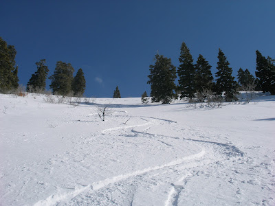
| First run, 700 vert, 38 degree slope. |


