 |
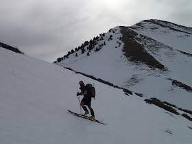
| Skinning up the south bowl of Rocky Peak, Lowe Peak seen to my right. |
 |
| Brett ascending Rocky Peak with Lowe Peak beyond (to his right). Our second run was from the summit of Lowe, down the bowl descending from the small saddle just below the high point. |
 |
| Brett ascending Rocky Peak. As the name implies, Rocky Peak is the Rocky Peak. |
 |
| View north, across the drainage on the north side of Rocky Peak. |
 |
| Brett ascending Rocky, with Lowe Peak across the way. |
 |
| Brett wondering if he should ski to Tooele?? Go for it man, but give me your car keys. |
 |
| Rocky Peak Divide, about a quarter mile below the summit, with Lowe Peak just above (right) of the trees. |
 |
| Enough clear ground, and hard, crusty snow, that we booted the final ridge to the summit.. |
 |
| Rocky Peak dead ahead. We skied the slope just off Brett's left elbow. |
 |
| Me in the pearly gates. |
 |
| Brett in the pearly gates, Timp and Lowe beyond. |
 |
| "Free at last, Free at last, Thank God almighty I am free at last." MLK. It feels soooooo good to summit any peak! Summit of Rocky Peak (elev. 10,275), and all downhill from here, until Lowe. |
 |
| North view and Stansbury Island, from Rocky Peak. |
 |
| I make my own sun glasses. Next time I'll open my eyes. |
 |
| Brett on Rocky's summit, view west toward the Stansbury Mountains. |
 |
| Stockton below, Stansbury's above, Deseret Peak (11,028 ft) is the high point on the right. |
 |
| Look hard and you'll see our ski tracks down the south bowl of Rocky Peak (above) |
 |
| Small wet slide on the flanks of Lowe Peak. |
 |
| Brett ascending Lowe Peak, Rocky Peak above (to his left). We skied the open bowl below the summit rocks. |
 |
| Brett, working hard on his day off. |
 |
| Me, headed toward the saddle between Rocky and Lowe Peaks. |
 |
| Final approach to Lowe Peak, Brett overlooking the north face of Lowe, which looks like dang-great ski terrain. Timp is on the left. |
 |
| Me, heading up the final ridge to Lowe Peak. I was cautious about collapsing a cornice and going for a ride, but as you can see, no worries. |
 |
| Abandoned communications equipment near the top of Lowe, the shack only holds a few old iron and sulfur laced batteries. |
 |
| View NW from near the summit of Lowe. |
 |
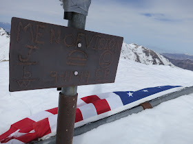
| Men of Vision need a lesson in patriotism . . . . |
 |
| From Lowe Peak (elevation 10,575), view south towards Flattop Mountain, the highest point in the Oquirrhs at 10,632 feet. Looks like some fun, steep ski lines off the north face. |
 |
| The central Wasatch as seen from Lowe Peak: Lone Peak mid-right, Little Cottonwood Canyon and Broads Fork Twins on the left. |
 |
| Your-truly on the summit of Lowe Peak, my fingers finally un-numb. |
 |
| View NW from Lowe, Rocky Peak and its south bowl (our first run) with Deseret Peak and the Stansbury Mountains beyond. |
 |
| Our second run ski track down the NW bowl of Lowe Peak. |
 |
| Second day on my new V6's and I'm already showing no respect. BTW, they skied great! |
 |
| The hike out required multiple stream crossings over slippery logs. The TLT6's stuck like glue. |
 |
| Evidence of another old slide path. |
 |
| I'm impressed with the ski potential of the Oquirrhs. Every side canyon revealed more and more potential. |
 |
| Open range in the Oquirrhs. First time - EVER - that I had to clean cow shit from my ski boots. |


We take too few days in the mountains, but the days we do take are most excellent.
ReplyDelete