Sunday, January 5, 2020

Cutler Ridge, Ben Lomand Divide, Bailey Creek, December 28, 2019

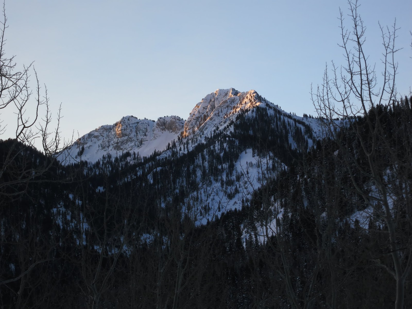
The east face of Ben Lomand Peak (9,712 feet) towering above Cutler Basin. 
Such a beautiful, spectacular, sunny, blue day up on Cutler Ridge today, but freezing! Such a welcome change from yesterday's gray day on Bountiful Ridge. My boots never dried completely from yesterday's tour so my feet were cold from the start. I couldn't feel them at all by the time we reached the Snotel site, which is 3 miles and 2,000 vertical feet from the trail head at North Fork Park (5,638 feet).  

I can normally handle the cold, but today I shivered the whole day. My chill was further complicated due to my hydration hose freezing so I couldn't drink. This was the first time - ever - that my hydration hose has frozen. I've read about others abandoning hydration hoses due to freezing, but I've never had a problem in the 15 years since I switched from water bottles. The problem I found with bottles is they are buried deep in my pack and much harder to get to, resulting in dehydration just from the hassle of stopping to dig in your pack for a drink. For awhile I used a belt pouch to hold a quart-size water bottle (strapped to my pack belt) but it was not always inconspicuous while skiing. When I had a quart of water swinging from my belt I could definatly feel it while skiing and if it was a steep, technical hill is was a negative distraction. My ski partners all go with bottles in their packs but they don't seem to be heavy sweaters like I am. I drink constantly to avoid dehydration so I need easy access and a hose provides that easy access. 

To avoid freezing, after I take a drink I blow the water back into the bladder, but from the start today I could not get any water to flow. I kept blowing into the hose and sucking, hoping I could break the ice-damn through pressure and hot-breath, but no luck. On frigid days I normally fill the bladder with hot water. It not only warms my back but it inhibits freezing. For this tour though, I packed everything the night before which meant the water had cooled to room temperature by the time I left this morning. When I got to Brett's house I put my pack in the back of Steve's truck for the drive from Ogden up to North Fork Park. The 45-minute drive from Ogden in the back of an unheated truck likely started the freezing of my water.  

Although the temperatures were in the single digits I was still sweating heavily - like I always do when skinning up a mountain - and without properly hydrating I got dehydrated. Dehydration decreases your body's ability circulate blood flow (warmth) to the extremities, so I was freezing almost from the start. My feet were cold from the start and soon so were my fingers. I always wear light mitten liners but today they weren't up to the task. It's always a battle to minimize sweating to avoid getting wet which robs your body of warmth once you stop for food, or water or transitioning to ski, so over-dressing is big mistake while skinning. In an effort to warm my fingers while skinning, I dragged my poles from the wrist straps, keeping my fingers next to my body or in my armpits. The skin track on Cutler Ridge is fairly low-angle so I never really needed my poles to lean into the hill or for balance while skinning up steep grades, and that really saved my frozen fingers from freezing. Yes, I had heavy, warm mittens in my pack, but I didn't want to bugger them up with sweat. I was saving them for the descent. If I had two pairs of wet gloves then I'd really have a problem, so I left them in the pack and used the no-pole skinning technique. 

I also carry extra base layers to change out of the wet layers at the top of ski runs. I strip to bare skin and put on dry layers and this almost always bring instant warmth but today it brought only a slight improvement. I was chilled and couldn't get warm, I hadn't felt my feet in over an hour so I was done after one ski run down Bailey Creek. Steve descended with me but Brett and Chris went back up to the divide for another run. I can't blame them as the snow was as good as it gets: ten inches of new, low density snow on top of a firm base, which is perfect for both ease of skinning and for the joy of skiing powder. So Steve and I went and sat in his truck while Brett and Chris skied. My toes never regained much feeling until I got home and then they burned and ached for several days afterward. 
They seem fine now but I was probably in the early stages of frost-bite, so I have no reservations about bailing on the day.      

Sunrise on the lower Cutler Ridge skinner in North Fork Park.

Chris, Brett and Steve, where the skinner leaves the groomed Nordic track and starts up the single track.

Steve and Chris just above the Snotel with Ben Lomand Peak emerging from the clouds.

Brett with Ben Lomand directly above. We skinned up to the divide just above and left of Brett's left shoulder, which is at the base of the Ben Lomand head-wall, about 1,000 vertical feet and 3/4 mile from the summit. From the divide we skinned south (left) 1/8 mile to that small gap in the trees on the ridge, transitioned to ski, then skied down Bailey Creek drainage which is the gladed face just to the right of the big Douglas fir on the left side of the photo.  

Brett getting closer to the Ben Lomand Divide.


View SW over Ogden valley. James Peak (Powder Mountain) is covered in clouds, left of the Douglas fir. 

Ben Lomand through the trees.

Ben Lomand

View north from Cutler Ridge and Willard Peak through the trees.

The east face of Ben Lomand Peak from Cutler Ridge. Big face and prone to slide, but great skiing when conditions are stable.


Willard Peak with Cutler Basin to the left (south).

Chris and Steve on the skinner to the Ben Lomand divide.


Saturday, January 4, 2020

Searching for the Northwest Passage, December 27, 2019

Ahhhhh, glorious sunshine after hours of bushwhacking in dense, white-out fog while searching for a new route up Bountiful Ridge. The sunshine was the reward of an otherwise gloomy, unproductive day.

"People seldom do what they believe in. They do what is convenient, then repent." - Bob Dylan

You know the feeling you get when you've given someone a huge gift and they ridicule your efforts?

I recently met a group of skiers on my access cut, I was ascending while they were heading down. Our conversation was friendly and cordial until they recognized my face, then their attitudes suddenly turned cold. Weird, but their loss. As we parted ways I overheard one of them mumble something to the affect of, "THAT is the ass-wipe who actually thinks he owns this place??"

Sometimes you win, sometimes you lose, and sometimes it rains. Like politics, religion and BC skiing (it's a sad day when BC skiing is classed with politics and religion) there are people that just don't like you, and that's OK.

Time to get back to my roots, crashing through brush looking for the Northwest Passage, a new route up to Bountiful Ridge, just to get off the beaten path again. It's fun to go where no-one else is willing to go. My new approach is starting to come together. It is longer and steeper than the North Canyon/Kara's Pot Farm approach, but it's a lot of fun to explore new areas again, like the good-old days in North Canyon. This is an approach that others disregard as too grungy (aka long and brushy). During my four days of exploring I didn't see another soul up there and that alone is a victory. Admittedly, the new route is tough because, like North Canyon five years ago, I'm once again fighting an endless sea of Gamble Oak. Very little cutting is taking place. Any cutting is very selective and it's only done in desperate situations, like where I could rip in my Walmart cotton sweats ($8.99) that I call backcountry ski wear. The route will be barely wide enough for a skinner. It won't really be ski-able as a descent route unless one has the confidence and ability to make hockey-stops in tight trees on a steep slope. If it was made as wide as KPF it would only invite the riff-raff who otherwise don't have an adventurous bone in their bodies. To keep cutting to a minimum, natural bald spots (islands in the sea of oak) will be used which will be linked together by natural drainage's where the brush is sometimes not as thick as on the hillsides. In short, it's a garbage approach, but I have a garbage soul, so I'm OK with it.

I don't intend to lose any friends here. I'd be glad to show anyone this new route but only if you are willing to take a blood oath, on your mothers name, with LDS Temple Recommend solemnity, with your deepest, most heart-felt honesty/integrity as a back-stop, promising that you will never, ever share details of the route with anyone, verbally, electronically, or otherwise.


New approach, steep, gamey and still thin over.

This is on my ascent and this is about a 37 degree slope. I tried skiing across this on the descent and thrashed my skies. 

Daggers hidden in the snow. Don't fall, or hook a tip. Could be deadly.

Beautiful dead tree in thick fog. Not eerie, rather, I get a charge from seeing these old monuments. They make me wonder how old they are and what this world was like when they took route. 

Signs of Chickadees everywhere. I love to see birds in the winter. So strong.


In thick fog and on a new route, I got lost. Nothing looked familiar. I kept referring to my watch for compass directions and the elevation to try to get an idea of where I was in relation to Bountiful Ridge.


Just hanging out in the fog. I kept hearing what I thought were human voices, which made me think I was nearing the top of Bountiful Ridge. I would stop skinning in an effort to hear more clearly, then the voices would go silent. I'd start skinning again and the voices would return, so I'd stop to listen again and of course the voices went silent again. After four or five starts and stops I looked up and saw these ravens, which were the source of the voices. Like I said, the birds up here in the winter are incredibly tough.

Where am I? Mark's Ghost Buttress or Crescent Ridge?? I was lost until I saw this dead tree, and when I saw it I knew exactly where I was, a familiar sight on Rectangle Ridge. Very strange feeling to not be where you thought you were.

Nearing Rectangle Peak the fog started to thin. . . 

 . . . and suddenly the sun exploded with brilliant, blue sky, revealing Crescent Peak and Crescent Bowl across the way.

Rectangle Ridge

View SW toward the Oquirhs, the fog hiding City Creek Canyon and Salt Lake City below.


Fog induced hoar frost.

View NW and my skin track up Rectangle Ridge. This photo was used by KSL weather on their nightly news for three nights this week. I have no patience for real photography. My formula for success, if you can call it that, I take thousands of photos and once in awhile one will turn out OK. 

The best selfies are faceless (you've heard me say that how many times??) View north and Session's Mountain, from Rectangle Ridge. 

Crescent Bowl with Blacks Peak, the pointy high-point in middle of the photo.

Not a track in sight.

Hoar frost and blue sky. The sun was such a welcome sight after skinning in gloomy, gray fog for three hours in unfamiliar country.

View SW from Rectangle Peak. Salt Lake City is directly below. 

Thursday, December 26, 2019

Bear Trap and Willow Fork, December 18, 2019

Kessler from Bear Trap


Went up Bear Trap and into upper Willow Fork today. 

I don't ski the Central Wasatch very often, primarily because I get totally stressed when I can't find a freaking parking spot at Spruces. With no parking available we look elsewhere and today that meant  Bear Trap, just up canyon from Spruces. We park and then I start popping Xanax to cope with the underlying anxiety that comes when skinning up the labyrinth of side-walk-wide/hard, human-urine-bombed skin tracks, spider-webbing their way up every hint of a drainage, just to take a spot in line to ski the glades off the Park City Ridge line. Only a sick mind would actually pay huge sums of cash to go wait in line at Disneyland, but here we are. OK, perhaps I have a flair for the dramatic, but you have to admit, the Central Wasatch is way, way, WAY overcrowded, the reason why we are now experiencing a huge spike in humanity in the grungy areas outside of the Central Wasatch. But I get it. The Central Wasatch offers big, beautiful skiing with mindlessly-easy access, and once it gets tracked-out, and it does get tracked-out, quite quickly in fact, the folks who still value solitude and fresh turns look elsewhere, thus the outlying Wasatch areas are now a destination and no longer just a 'Meh' to B.C. skiers. 

It hasn't snowed in over a week and the sun has been doing its work. It was sunny and calm, but cold! A lot of sun-crust but a few soft spots still remain in the trees. With the frigid temps I wore my shell most of the day, and, with my beacon and camera strapped to my belly under the shell, I look like a total fatty, which is a fun conversation killer when we pass a group of bad-ass youngsters who look at my gray beard, then my belly, then my gray beard again, then, to emphasize the fact they were being passed by two old, bald men, mumble something about a "bad knee from church ball" and, "they had to use old their old, rail-binding rigs because they had no time to cut new skins for their new kit." Blah, blah, blah. Excuses only bring a laser focus to that which you are trying to hide. I respond, "it's no race, leave that for the SkiMo crowd who give a shit." Uncomfortable silence follows, presumably they don't like my use of the 'S-word,' of which, I hear much worse every Sunday at church, but, conversation over, we move on. 

We ski Bear Trap Glades, Willow Fork West, and Bear Trap Glades again. Holy crap! It's shocking how it looks more like a ski area than the back country because it is totally tracked! Exclamation on the OUT! Whining aside, I only have myself to blame. If one is willing to work and cover longer distances, there is plenty of untracked terrain in the Central Wasatch. Maybird and Hogum have a much greater barrier to entry than the 'side-country areas.' Oh well, my annual experiment with the central Wasatch has come and gone. Although, I feel a strong draw to Hogum, buts that's another day....


Sunrise on Kessler

More Kessler

and more Kessler, the Catcher's Mitt, the BC ski run is the broad open bowl on the east side of Kessler.

The Cone, which is regularly skied-out like a ski area, testament to the explosion of humanity in the back country.

"Look at me!! I've got skins and a beacon and everything!" - Side-Country Bob.

This is the summit of 9,990, the Canyon's/Park City's highest ski lift, owned by Vail Ski Corp. It terminates 200 feet below the Park City Ridgeline and it's an access gate for side-country skiers (skiers who ride ski lifts to gain access to out of bounds terrain, which is not controlled for avalanches), not to be confused with back country skiers who are get to the same places but under 100% human power.

Since this lift was installed in the early 2,000's, there have been five avalanche deaths on nearby slopes and those five deaths were folks who rode the lifts to the top of 9,990, ducking the rope, hiking a short distance, then skiing an unstable slope that avalanched, buried and killed them. Call it what you will, personal freedom vs. regulation, but before the days of open access one would get ticketed and fined for leaving resort boundaries, so there were much fewer people skiing those slopes. It was completely legal to ski those slopes, but illegal to ride the lifts then duck the ropes. The physical effort to hike up the mountain in deep, soft snow is a barrier to entry which weeds out many people who would otherwise ski these slopes. As cold and harsh as it might sound, that barrier to entry saves lives. I'm not suggesting, even remotely, that back country skiers are more safety conscious than side-country/resort skiers, just that with easy access there are a lot more people now accessing those slopes than ever before, so the odds of unsuspecting skiers accessing unstable slopes has increased with open access from ski lifts. 
Sunrise on the Park City Ridgeline.

The Colony, the Canyon's lift-served elite housing development, as seen from the Park City Ridgeline.

B. Fuller on the Park City Ridgeline with the Central Wasatch behind.


The sidewalk in upper Bear Trap Fork. So rock hard if I ever got complacent and didn't feather the plush of my skins, they would suddenly lose purchase and I'd skate backwards. Ouch! A recipe for a pulled groin for an old, bald man. 

Mt. Raymond (l), Gobblers Knob (r).

Hoar frost developing.

Brett on the divide between Bear Trap Glades and West Willow Fork, with Dromedary and Broads Fork Twins on the skyline directly above Brett's head. The dominant bowl above his left shoulder
 (looker's right) is the Catcher's Mitt on Kessler.

I love birds and love to see signs off Chickadee's searching for a meal.

West Willow Fork, looking up towards the divide with Bear Trap Fork.

View over to the east side of Willow Fork, with Willow Knob and Little Willow (BC ski run) in center.

Last year's aspens . . . 

Aspens, sun and snow, a glorious combination.

Ot-ohh! Coyotes in the SLC watershed. 

The Wasatch is off to a good start but we need more snow, mostly to cover all the old tracks.

Our attempt at a figure eight. Tight '70's turns in sun-crust, a recipe for . . .  "why?"

West Willow Fork.

Tracks in West Willow Fork with silver Fork Meadows, Days Fork, Cardiff Fork (and Superior and Monte Cristo at the head), Mineral Fork (barely visible) above with Dromedary on the far right. 

View NW over the the Desolation divide (near ridge) and Peak 9,990 on the right.


Brett topping out above Bear Trap Glades (r) and West Willow Fork (l).


Lots of tracks, feels like the Epic, Icon and WTF passes now include the Wasatch BC.